🔸️🔸️🔸️ Tonight in Duke of Edinburgh Award was all about maps 🗺 for expedition training. Learning included:
🚶♀️🚶🚶♂️ Pacing - Pacing is the counting of double paces to determine the distance covered. Young people need to establish how many paces it takes them to cover 100 metres on various types of terrain.
📏✏📐 Distances - Being able to measure the distance between two points on a map is very important. It allows you to work out what distance is in real life and will give you a good idea of how long your journey will take. Young people had to pick out buildings in the village and guess the distance from the community centre, before looking at the map and learning how to measure the distance correctly. Two ways of doing this is by using a piece of paper or string to trace their chosen route, then measuring it using the scale bar on the map.
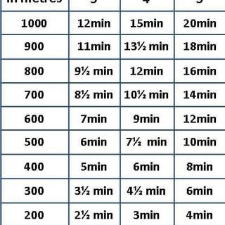
🕑⏱🕰 We also looked at walking timings. So that we know how long it will take us to get from one leg of our journey to another. Naismith's Rule, allows an easy calculation of the time taken for a hill walk, for a reasonably fit and steady walker: 15 minutes for every kilometre of horizontal distance, plus 10 minutes for every 100 metres of ascent. The time should be calculated for the slowest person in a walking group.
🚾🖼♿ We finished the session with a game of map symbols bingo. To help us learn all the different symbols on an ordinance survey map.
👌🤘👍 All essential skills that the group will need to be able to plan and safely complete their training day walks and qualifying expedition.
***PLEASE NOTE: OUR DOFE GROUP IS NOW FULL***


Comments